
Corridor Beyond Madison Lane Profile Design
A civil engineering profile drawing showing the proposed Madison Lane corridor alignment, elevation changes, station points, grades, and vertical curve information. The plan includes a roadway profile chart, existing and proposed grade lines, contour-based alignment reference, scale details, and project title block information for the Corridor Beyond development.
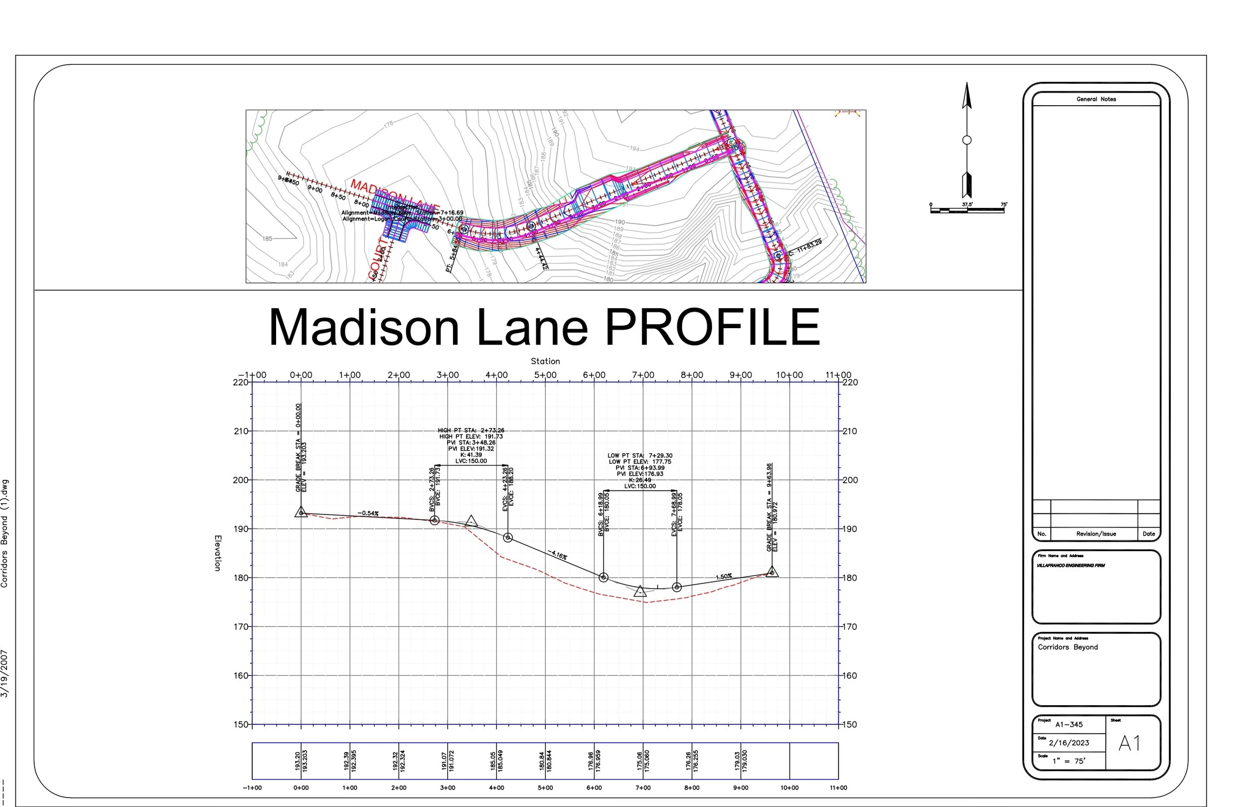
Madison Lane, showing the roadway alignment, ground elevations, proposed grades, and design information needed for construction and review. The drawing is arranged in a professional plan-sheet format with a plan view, profile view, scale reference, north arrow, notes area, and title block.
Plan View / Road Alignment
The upper portion of the sheet shows a plan-view layout of Madison Lane. It includes the horizontal roadway alignment, nearby connecting roads, contour lines, station labels, and colored design markings. This view helps identify the roadway’s position, curves, intersections, and surrounding terrain conditions.
Existing Terrain and Contours
The background contour lines represent changes in ground elevation across the project area. These contours help show the natural slope of the land and how the proposed roadway design relates to the existing topography.
Profile View
The main center graph displays the longitudinal profile of Madison Lane along the roadway stationing. It shows how the road elevation changes from one station to another, allowing the viewer to understand rises, drops, and slope transitions along the corridor.
Stationing
The profile is organized by station numbers along the roadway, ranging approximately from -1+00 to 11+00. These station labels are used to locate specific points along the road and connect the profile information to the plan-view alignment.
Elevation Data
The vertical axis shows elevation values, approximately from 150 feet to 220 feet. Elevation callouts are included at important points to document the designed roadway height and compare it with existing ground conditions.
Proposed Road Grade
The solid profile line represents the roadway grade and includes slope labels between key points. These grade percentages show how steep or flat each roadway segment is, which is important for drainage, vehicle movement, and construction accuracy.
Reference / Existing Ground Line
The dashed red line appears to represent an existing ground profile or reference grade beneath the roadway design. It helps compare the proposed road surface with the natural terrain and shows where grading, cutting, or filling may be required.
High and Low Points
The profile includes labeled high-point and low-point information. These points identify where the roadway reaches local maximum or minimum elevations, which is especially important for drainage design and vertical curve planning.
Vertical Curve Information
Several notes on the profile indicate vertical curve and grade transition details. These annotations help define smoother roadway transitions between slopes, improving comfort, visibility, and constructability.
Drainage Considerations
The low-point information suggests areas where water may collect or where drainage design must be carefully coordinated. These points are important for locating inlets, swales, or other stormwater management features.
Scale and Orientation
The sheet includes a north arrow and graphic scale near the plan view. These elements help users understand the drawing orientation and approximate real-world distances shown on the plan.
General Notes and Revisions
The right side of the sheet contains a large general notes area and a revision table. These sections are used to record design notes, project updates, issue dates, and drawing changes during the engineering review process.
Project Title Block
The title block identifies the project as Corridors Beyond, with the drawing focused on the Madison Lane Profile. It includes project information, sheet number A1, date 2/16/2023, and scale 1" = 75'.
Overall Purpose
Overall, this drawing communicates the planned roadway elevation design for Madison Lane. It combines plan and profile information to support civil design review, grading coordination, roadway construction, and project documentation.